NOAA Office of Satellite and Product Operations
Pre-Prod

Polar Navigation

EarthMap

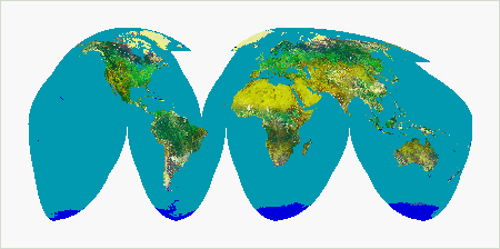
Polar Navigation/Earth Location: This image is a Homolosine projection of the Earth prepared from Advanced Very High Resolution Radiometer(AVHRR) data.
(Credit: ESA/NASA/NOAA/USGS/CSIRO)

Overview of NESDIS Polar Earth Location Process

Graphical Orbit Locator

Below is a link to the self-extracting file XTRCTORB.EXE. to your harddrive (this file cannot be processed directly from a browser.) This version can be run only under DOS. It is recommended that it be placed in a subdirectory of its own. Changing to this subdirectory and running XTRCTORB will generate the program GNRLORB.EXE and its associated files. Running GNRLORB and inputting the longitude of the ascending node, available in the equator crossing files, will plot the subtrack of a nominal NOAA-n satellite with marks at five minute intervals from ascending node, and the limits of an AVHRR scan on a choice of map bases:


  • Rectangular equal spaced projection from 70 degrees south to 70 degrees north latitude;
  • Northern hemisphere polar stereographic projection; and
  • Southern hemisphere polar stereographic projection.

Optionally, the date and time of the ascending node, available in the equator crossing files, may be entered. In which case the sub-solar point and the terminator are plotted for the beginning and end of the orbit. More information about this file is given in the extracted READ.ME file.

Download: Graphical Orbit Locator

Polar Satellite Equator Crossing Information

The equator crossing data given here is for ascending (northbound) nodes, with the longitude measured eastward. The date and time are presented in two forms:


  • Modified Julian Date (04D): The 04D is Astronomical Julian day (not day of year) minus 2400000.5 (such as 50204.9988306)
  • Gregorian Calendar date and time with four digit year, month, day, hours, minutes, and seconds, such as: 1996   5   1   23  58   18.96

METOP-03(C) Equator Crossing Data Current Weekly Archive
METOP-01(B) Equator Crossing Data Current Weekly Archive
NOAA-19(P) Equator Crossing Data Current Weekly Archive
METOP-02(A) Equator Crossing Data Current Weekly Archive
NOAA-18(N) Equator Crossing Data Current Weekly Archive
NOAA-17(M) Equator Crossing Data Latest Data Weekly Archive
NOAA-16(L) Equator Crossing Data Current Weekly Archive
NOAA-15(K) Equator Crossing Data Current Weekly Archive
NOAA-14(J) Equator Crossing Data Latest Data Weekly Archive
NOAA-12(D) Equator Crossing Data Latest Data Weekly Archive
NOAA-11(H) Equator Crossing Data Latest Data Weekly Archive

Clock Drift Files for Polar Satellites


NOAA-19(P) Clock Drift File Last revised: 3/21/2024
NOAA-18(N) Clock Drift File Last revised: 3/21/2024
NOAA-17(M) Clock Drift File Last revised: 6/27/2012
NOAA-16(L) Clock Drift File Last revised: 6/3/2014
NOAA-15(K) Clock Drift File Last revised: 3/21/2024
NOAA-14(J) Clock Drift File Last revised: 12/29/2005
NOAA-12(D) Clock Drift File Last revised: 12/29/2005
NOAA-11(H) Clock Drift File Last revised: 11/1/2002

Other Links