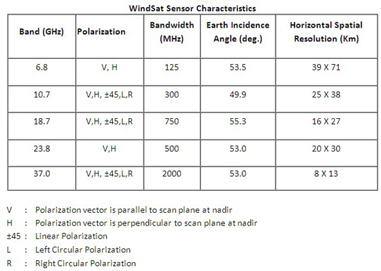
WindSat OverviewNOTE: WindSat is no longer a part of SMOPS. It is replaced by AMSR-2. WindSat is a satellite-based polarimetric microwave radiometer aboard the joint DoD/Navy platform Coriolis that measures ocean surface wind vectors. The Coriolis satellite, launched in January 2003, orbits Earth at an altitude of 840 km in a Sun-synchronous orbit. The satellite completes just over 14 orbits per day. The orbit and antenna geometry result in a forward-looking swath of approximately 1000 km and an aft-looking swath of about 350 km. The fully integrated WindSat payload stands 10 ft tall and weighs approximately 675 lbs. The WindSat payload is a multi-frequency polarimetric radiometer nominally operating in discrete bands at 6.8, 10.7, 18.7, 23.8, and 37.0 GHz. The table below provides key design and performance parameters of the system. The 10.7, 18.7, and 37.0 GHz channels are fully polarimetric. The 6.8 channel is dual-polarization (vertical and horizontal), and is more sensitive to sea surface temperature (SST) than to winds. Thus it is used to remove measurement noise due to variations in SST. Similarly, the 23.8 channel has dual-polarization. This frequency responds strongly to water vapor in the atmosphere, which attenuates the signal from the ocean surface. Thus, 23.8 channel data mitigates the effects of the water vapor. More detailed information may be found at the NRL Windsat web page at www.nrl.navy.mil/WindSat.
|