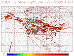
| Snow Depth (SSM/I) | Product shows snow depth over land. The snow depth is derived from the passive microwave sensor SSM/I, which has 7 channels of 19 GHz (H, V), 22 GHz (V), 37 GHz (H, V), and 85 GHz (H, V), where H is the horizontal polarization, V is the vertical polarization. The snow depth measures the depth of recently accumulated dry snow, which varies from 0 to 400 with accuracy of 1 mm. The product is updated once per day at 4 am EST.
This product is originally generated by Fleet Numerical Meteorology and Oceanography Center (FNMOC). NOAA/NESDIS gets the product through an interagency program referred to as the Shared Processing Program in which NOAA, the US Air Force and US Navy participate. OSDPD converts the product into HDF-EOS and WMO BUFR formats and distributed to users. Product Link |
|
|
||
| POES (DMSP) | Resolution: 25 km | Frequency: Daily |
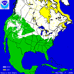
| IMS Snow and Ice Cover - NH | This National Ice Center product shows daily snow and ice cover for the Northern Hemisphere, Continental United States, Alaska, Afghanistan and Asia/Europe. It is a human-based manual analysis derived from a multitude of data sources, including GOES, Meteosat, Himwarai, SAR, VIIRS, MODIS, POES AVHRR and many derived data sources. The products are available in 1-km, 4-km and 24-km resolutions. The National Ice Center (NIC), is comprised of personnel from NOAA, The United States Navy and The United States Coast Guard.
Product Link |
|
|
||
| GOES and POES | Resolution: 1, 4 and 24 km | Frequency: Daily |
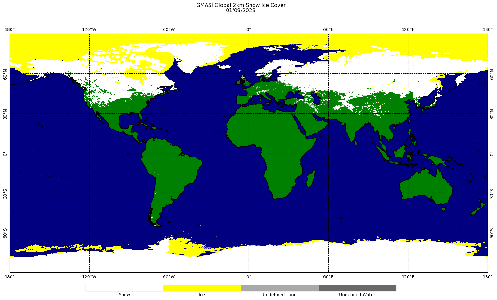
| AutoSnow - Snow and Ice Cover |
The Global Multisensor Automated Snow and Ice mapping system (GMASI) uses the synergy of observations in the visible, infrared, and microwave spectral bands from operational polar-orbiting and geostationary satellites to generate daily global maps of snow and ice cover. The current version of the system incorporates data from the following satellite sensors: METOP-B/C AVHRR, GPM GMI, and GCOM-W1 AMSR2. This 2-km resolution analysis has a full global coverage on a 9000 x 18000 grid. The products are available in NetCDF and GRIB2 formats. (The daily snow and ice maps will be archived at NCEI/CLASS for public user access).
Product Link |
|
|
||
| POES and GOES | Resolution: 2km | Frequency: Daily |
| Automated Snow Mapping System | The automated snow mapping system is based on a synergy of GOES-Imager, NOAA-AVHRR and DMSP-SSM/I data and produces daily snow cover maps for the North American continent.
Product Link |
|
| GOES and POES | Resolution: 1/25/Degree | Frequency: Daily |