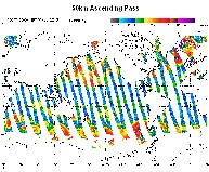
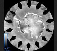
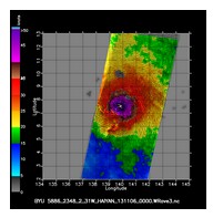
NOAA Office of Satellite and Product Operations

ASCAT - Advanced Scatterometer

The Advanced Scatterometer (ASCAT) winds products are processed by NOAA/NESDIS utilizing measurements from the scatterometer instrument aboard the EUMETSAT Metop satellites. The instrument uses radar to measure backscatter to determine speed and direction of winds over the surface of the oceans. ASCAT data feeds numerical weather prediction models, provides useful information on ice, snow and soil moisture, and is used to analyze areas of individual storm activity. The following images are available:

Surface Winds Images

Surface winds images are created hourly for ascending and descending 25 km and 50 km data. Daily images are archived for 7 days. The following link provides wind product monitoring information in near-real time: OSI SAF ASCAT-A 25-km monitoring

Sample Winds image

Ice Images

Daily ice images are created for five regions: Alaska, Antarctica, Arctic, Ross Ice Shelf, Weddel Sea

Sample ICE image

UHR Winds Images

Ultra High Resolution (UHR) winds images are created every three hours for sectors containing a storm or an area of interest that might become a storm.

Sample UHR image