Weekly GOES-17 RSTU OSPO INR Website Report
Report Time Range: 2019/328-0 to 2019/335-0
Satellite ID: GOES-17
| Band |
1 (VNIR 470 nm) |
2 (VNIR 640 nm) |
3 (VNIR 865 nm) |
5 (VNIR 1610 nm) |
6 (VNIR 2250 nm) |
| EW |
91.8944% (3968/4318) |
100.0000% (7788/7788) |
100.0000% (7530/7530) |
100.0000% (7369/7369) |
99.9256% (6714/6719) |
| NS |
100.0000% (4318/4318) |
100.0000% (7788/7788) |
100.0000% (7530/7530) |
100.0000% (7369/7369) |
99.6428% (6695/6719) |
ABI MWIR/LWIR Full Disk Navigation (NAV) Landmark Residual Points Within Limit (Green = above 99.7 % spec)
| Band |
7 (MWIR 3900 nm) |
11 (MWIR 8500 nm) |
13 (LWIR 10350 nm) |
14 (LWIR 11200 nm) |
15 (LWIR 12300 nm) |
16 (LWIR 13300 nm) |
| EW |
99.0394% (26599/26857) |
98.6989% (19192/19445) |
99.0508% (20035/20227) |
98.7880% (18014/18235) |
98.0940% (14462/14743) |
98.9437% (843/852) |
| NS |
99.4378% (26706/26857) |
99.2286% (19295/19445) |
99.7231% (20171/20227) |
99.7861% (18196/18235) |
98.4399% (14513/14743) |
96.3615% (821/852) |
ABI VNIR Full Disk Frame-to-Frame (FFR) Landmark Residual Points Within Limit (Green = above 99.7 % spec)
| Band |
1 (VNIR 470 nm) |
2 (VNIR 640 nm) |
3 (VNIR 865 nm) |
5 (VNIR 1610 nm) |
6 (VNIR 2250 nm) |
| EW |
100.0000% (14039/14039) |
100.0000% (16172/16172) |
100.0000% (17959/17959) |
100.0000% (19751/19751) |
100.0000% (18217/18217) |
| NS |
100.0000% (14039/14039) |
100.0000% (16172/16172) |
100.0000% (17959/17959) |
100.0000% (19751/19751) |
100.0000% (18217/18217) |
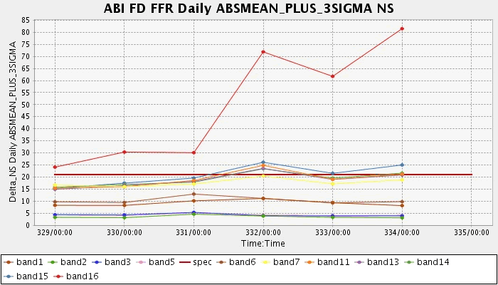
ABI MWIR/LWIR Full Disk Frame-to-Frame (FFR) Landmark Residual Points Within Limit (Green = above 99.7 % spec)
| Band |
7 (MWIR 3900 nm) |
11 (MWIR 8500 nm) |
13 (LWIR 10350 nm) |
14 (LWIR 11200 nm) |
15 (LWIR 12300 nm) |
16 (LWIR 13300 nm) |
| EW |
100.0000% (54728/54728) |
99.9739% (42130/42141) |
99.9737% (41788/41799) |
100.0000% (39060/39060) |
99.7941% (32954/33022) |
70.4658% (2133/3027) |
| NS |
99.9909% (26706/26857) |
99.7295% (42027/42141) |
99.8588% (41740/41799) |
99.8490% (39001/39060) |
99.2641% (32779/33022) |
82.2927% (2491/3027) |
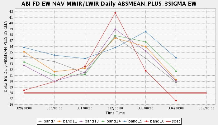
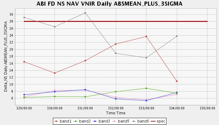
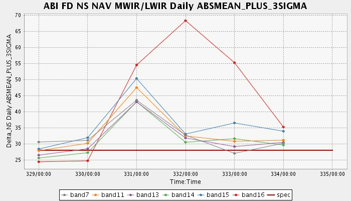
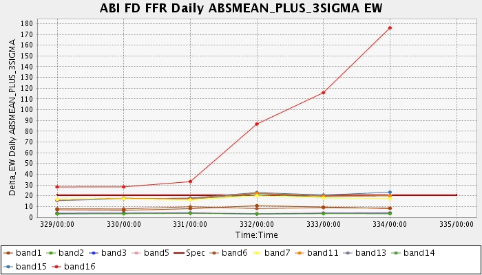
Plots
Each plot point represents the absolute mean plus 3 standard deviations for the full disk landmark residuals in that day.