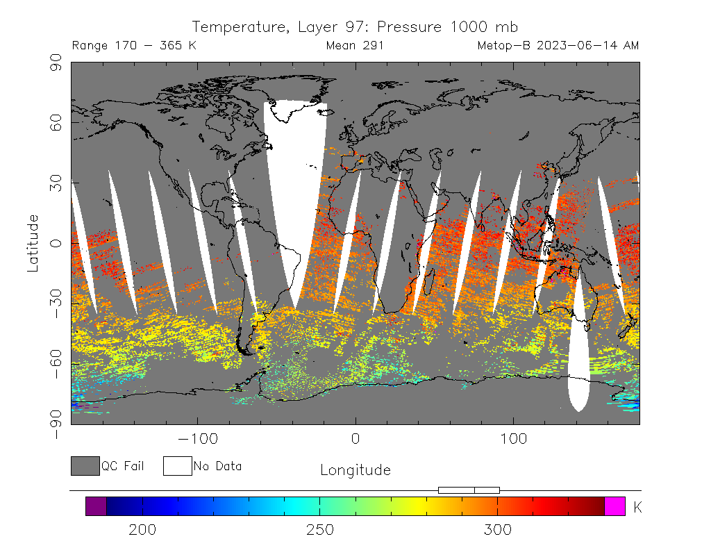
The Advanced TIROS Operational Vertical Sounder (ATOVS)
data processing system provides near real-time atmospheric temperatures at 42 levels (from surface to 0.1
mb) and water vapor mixing ratios at 19 levels (from surface to 200 mb) with a 40 km horizontal resolution
derived from the AMSU-A and HIRS measurements on board the NOAA polar orbiting and European MetOp satellites
series. The primary functions of the system are to quality check the instrument data, convert it to
radiances (or brightness temperatures), limb correct, cloud clear for the ATOVS, determine a first guess
profile and compute the retrieval. Cloud detection is done using AVHRR channels 3b, 4, and 5. In addition to
the temperature and moisture profiles, ATOVS products suite includes the AMSU-A brightness temperatures,
HIRS channels radiances, layer temperatures and layer thicknesses (15 layers with 40 km resolution),
geopotential heights, tropopause pressure, tropopause temperature, total ozone, cloud amount, cloud top
temperature, cloud top pressure, layer precipitable water, cloud liquid water and total precipitable water
in binary and BUFR format.
The Infrared Atmospheric Sounding Interferometer (IASI) onboard the European MetOp satellite, was launched in October 2006. IASI produces temperature and humidity profiles with vertical accuracies of 1 degree Kelvin and 10 % per 1-km layer respectively. The first priority of the IASI processing system is to generate radiance products from data ingested in a pipeline mode from EUMETSAT. These radiances undergo sub-setting, Principal Component Analysis (PCA) reconstruction, and global gridding. Subsequently these radiance products are distributed to users as BUFR, NetCDF and BINARY files. All levels of data products are made available at the user specified locations, as subset files, and as gridded subsets.
The NOAA Unique Combined Atmospheric Processing System (NUCAPS) was developed to generate (1) spectrally and spatially thinned radiances, (2) retrieved products such as profiles of temperature, moisture, trace gases and cloud-cleared radiances, and (3) global validation products such as radiosonde matchups and gridded radiances and profiles. The thinned radiance products are produced in BUFR format using the NetCDF4 Reformatting Toolkit (N4RT) and are tailored to specifically Numerical Weather Prediction (NWP) centers. The NUCAPS Environmental Data Records (EDR) products are archived in Comprehensive Large Array-Data Stewardship System (CLASS) for non-real time users.
These products are derived from the Cross-track Infrared Sounder (CrIS) and Advanced Technology Microwave Sounder (ATMS) currently onboard the Suomi National Polar-orbiting Partnership (SNPP) satellite and later will be available from the Joint Polar Satellite System (JPSS-1 and JPSS-2).
The POES Temperature and Moisture Soundings Profiles are displayed in Skew-T Log-P diagram format. These diagrams include both the POES and the first guess (model data). Also included are several derived parameters to the right of each diagram. Profiles included in the diagram are POES derived Temperature, Guess Temperature, POES Dew point , Guess Dew point, and POES Parcel with positive and negative areas. The POES thermal gradient winds (derived from the Soundings) are also displayed on the diagrams. The background image is generated from the AVHRR composite on the same platform as the ATOVS. The global map has been split up into several regions and regions are divided into 1 degree X 1 degree grid for the profiles. You may be able to select a region of interesting from the global map.
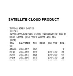
The GOES Satellite Cloud Product (SCP) is a text product that compliments the National Weather Services (NWS) Automated Surface Observation System (ASOS). These text products, sometimes referred to as ASOS SCP, detect the cloud cover conditions over the ASOS stations, and list them by state.